The park is situated in the extreme west of Uganda in Bundibugyo District. It lies along the Uganda/ Democratic Republic of Congo border within the western arm of the East African Rift valley. In the south east are the Mount Rwenzori Mountains, to the west is Democratic Republic of Congo and to the north are the Semuliki Flats and Lake Albert.
The park is 220 square kilometres and occupies flat and gently undulating terrain raging from 670metres – 760metres above sea level. The average annual rainfall is high at 1,250mm that peaks from March to May and again from September to December. The temperatures vary from 18 degrees centigrade to 30 degrees centigrade with relatively small daily variations.
Wildlife diversity
The park is the only lowland tropical rain forest in East Africa classified as moist and semi deciduous. There are 336 tree species recorded, 374 species of butterflies, 63 species of mammals and 9 species of primates. These include: chimpanzee, blue monkey, vervet monkeys and olive baboons while the nocturnal primates include pottos and galagos. Also to be found are Forest buffalo, blue duiker, bee croft’s flying squirrel, pygmy squirrel, little collared fruit bat and target rat.
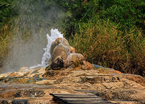
Other attractions include the Batwa people (pygmies) hunters gatherers that live a simple life style and depend on Semuliki forest for food. The meandering river Semliki, Sempaya hot spring. River Semliki is a shelter of water birds and crocodiles.
Activities
- Game viewing
- Bird watching
- Nature walks
Accommodation
Within the Semuliki Game Reserve accommodation is to be found at:
- Semuliki Safari lodge – Upmarket.
Access
The park is accessed via the town of Fort Portal in the west of the country. The Bundibugyo road that skirts the Rwenzori escarpment offers a wonderful scenic view at Munu ni Mkubwa where the road has promintary over the Semliki river and Sempaya hot springs. Driving time from Kampala 6 hours.